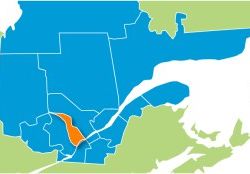
08 – Lanaudière

General Information:
The Lanaudière region is composed of the Laurentians and the Canadian Shield, a region of ancient mountains. In the south of the region, the terrain is undulating, while the gradients are more pronounced further north (Saint-Zénon and Saint-Donat). For the most part, trails go through mixed-growth forest.
Practical Information:
- Regional network:
18 clubs (2, 127 Km of trails) - Main trails:
3 at l’Assomption
33 at Saint-Donat
43 and 3 at Berthierville
63 at Saint-Edmond
345 near Joliette
310 at Rawdon
341 and 343 near Saint-Côme - Accommodation accessible from the trail:
800 to 1,000 rooms near the trails (more than 2,000 rooms in the region) - Snow conditions :
Some 30 kilometres north of Montreal: from mid-December until the end of February. North of Saint-Donat, Saint-Côme and Sainte-Émélie: until mid-March. In the Saint-Zénon region and Saint-Michel: until the end of March.
Location:
Immediately to the Northeast of Montreal, served principally by Highways 25, 31 and 40, and Highways 125, 131, 343 and 347. Although one can access trails directly from the Laval network, the most picturesque portion starts some 60 kilometres to the north where the terrain is more rugged.
Principal cities: Repentigny – L’Assomption – Berthierville – Joliette – Rawdon – Saint-Gabriel-de-Brandon – Saint-Côme – Sainte-Émélie-de-L’Énergie – Saint-Donat – Saint-Zénon – Saint-Michel-des-Saints.
Attractions:
- Montagne Noire at Saint-Donat (trail 33)
- Mont-Trinité at Saint-Michel-des-Saints (trail 318)
- Trails through preserves (Rouge-Matawin, Mastigouche)
- Ice sculpture festival at Saint-Côme in February
- The Gilles Villeneuve Museum at Berthierville
From the region:
- Laurentides at west (trails 33 et 63)
- Mauricie at east (trails 3, 63 et 349)
- Montérégie at south (trail 43 at Berthierville)
Links:
 |
3568, rue Church Phone : 450 834-2535 ou 1 800 363-2788 Site Internet: www.paysdelamotoneige.ca |
Secure Hotels
There are no secure hotels affiliated with the FCMQ in this region for the moment.


